In today’s rapidly evolving financial and social landscape, accurately assessing risk in high-risk ZIP codes has become more critical than ever. Whether for lenders, insurers, or community planners, understanding the unique challenges these areas face is essential to making informed decisions that promote sustainability and equity. Enter FirstStreet Tools—a powerful suite of data-driven solutions designed specifically to provide nuanced insights into the complex factors affecting high-risk neighborhoods. In this article, we’ll explore how FirstStreet’s technology can help organizations pinpoint vulnerabilities, evaluate risks comprehensively, and ultimately take smarter, more strategic actions in communities that need them most.
Table of Contents
- Understanding FirstStreet Tools and Their Role in Risk Assessment
- Identifying Vulnerabilities in High-Risk ZIP Codes Through Data Analysis
- Leveraging Predictive Models to Enhance Community Safety Strategies
- Implementing Targeted Interventions Based on FirstStreet Risk Insights
- Final Thoughts
Understanding FirstStreet Tools and Their Role in Risk Assessment
FirstStreet tools are pioneering resources designed to provide granular insights into community risk factors, especially in elevated-risk ZIP codes. By integrating comprehensive datasets such as census demographics, economic indicators, and hazard exposure, these tools enable users to visualize risk on multiple levels. This multi-layered analysis supports informed decision-making by highlighting vulnerabilities related to natural disasters, socio-economic challenges, and infrastructure weaknesses inherent to specific locales. The tools employ sophisticated models that translate raw data into actionable intelligence, allowing stakeholders to prioritize interventions effectively.
Utilizing FirstStreet involves several critical features that differentiate it in the realm of risk assessment:
- Real-time risk mapping: Dynamic visualizations update with evolving conditions, offering up-to-date risk profiles.
- Community resilience scoring: An index that evaluates a neighborhood’s capacity to recover from adverse events.
- Data customization options: Tailoring risk factors to suit specific project needs or regulatory requirements.
- Integration capabilities: Seamless incorporation with existing GIS and planning tools for comprehensive strategy development.
These functionalities collectively promote a proactive stance in managing risk, making FirstStreet an indispensable asset for urban planners, insurers, and emergency managers committed to safeguarding vulnerable populations.
Identifying Vulnerabilities in High-Risk ZIP Codes Through Data Analysis
High-risk ZIP codes often harbor complex socioeconomic and environmental challenges that can be difficult to pinpoint without comprehensive data analysis. By leveraging FirstStreet’s advanced data tools, analysts can sift through vast datasets to expose hidden vulnerabilities—from flood risk and healthcare access to socioeconomic disparities. These tools enable a multi-dimensional view that not only reveals where risks are concentrated but also uncovers underlying factors contributing to the fragility of these communities. This data-driven approach is critical for formulating more precise, effective mitigation strategies tailored to the unique needs of each ZIP code.
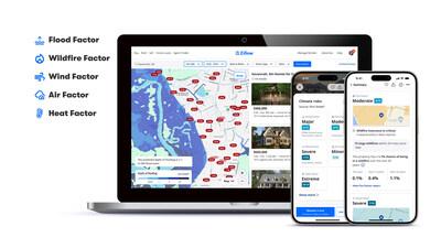
Using FirstStreet’s platform, stakeholders can visualize risk through dynamic mapping features and predictive analytics, allowing for easy comparison across various risk factors. Key capabilities include:
- Real-time risk scoring: Understand current vulnerability levels instantly.
- Layered risk overlays: Combine natural hazards with social and economic data to gain holistic insights.
- Customizable dashboards: Focus on metrics most relevant to your community or organization.
These functionalities empower decision-makers to prioritize resources effectively and implement interventions before vulnerabilities escalate into crises.
Leveraging Predictive Models to Enhance Community Safety Strategies
Predictive modeling has revolutionized the way communities approach safety by offering data-driven insights that pinpoint vulnerabilities before they escalate. By harnessing powerful analytical tools like FirstStreet, local governments can dive deep into high-risk ZIP codes to uncover patterns of risk linked to natural disasters, crime rates, and infrastructure weaknesses. This proactive approach enables officials to allocate resources more effectively, design targeted interventions, and foster resilience within the populations most in need. FirstStreet’s advanced algorithms process vast datasets, producing risk scores that translate complex variables into actionable intelligence for decision-makers.
Implementation of these models brings several advantages, including:
- Targeted Resource Allocation: Focus efforts on the areas identified as highest risk to maximize impact.
- Early Warning Systems: Predictive insights help anticipate potential crises, allowing for timely preparation and response.
- Community Engagement: Transparent sharing of risk assessments encourages public cooperation and awareness initiatives.
By integrating predictive analytics into their safety strategies, communities don’t just react to threats — they anticipate and neutralize them, fostering a safer environment that benefits all residents.
Implementing Targeted Interventions Based on FirstStreet Risk Insights
Utilizing FirstStreet’s granular risk data allows organizations to pinpoint vulnerability with unprecedented precision, enabling the deployment of interventions that truly make an impact. By analyzing metrics such as flooding potential, earthquake exposure, or hurricane risk at the ZIP code level, stakeholders can allocate resources more efficiently and tailor their strategies to the unique challenges of each area. Rather than a one-size-fits-all approach, these insights facilitate customized response plans that prioritize the safety and resilience of at-risk populations.
Key benefits of data-driven, targeted interventions include:
- Optimized resource distribution, ensuring aid reaches those who need it most.
- Enhanced collaboration between local agencies by providing a common, reliable risk framework.
- Improved community preparedness through tailored education and outreach programs.
- Reduced economic losses by focusing preventive measures on the highest-threat zones.
By embracing FirstStreet’s risk insights, agencies and businesses not only increase their operational effectiveness but also foster greater trust and resilience within communities. This data-driven paradigm shifts risk management from reactive to proactive, ultimately saving lives and preserving assets in the face of natural and environmental hazards.
Final Thoughts
In conclusion, leveraging FirstStreet tools to assess risk in high-risk ZIP codes offers a powerful way for businesses, policymakers, and community leaders to make informed decisions grounded in comprehensive data. By understanding the unique challenges and vulnerabilities within these areas, stakeholders can better allocate resources, plan interventions, and build resilience. As risks continue to evolve, embracing advanced analytics and localized insights through platforms like FirstStreet will be essential in fostering safer, more prepared communities. Staying proactive with these tools isn’t just smart—it’s necessary for impactful, responsible risk management.


